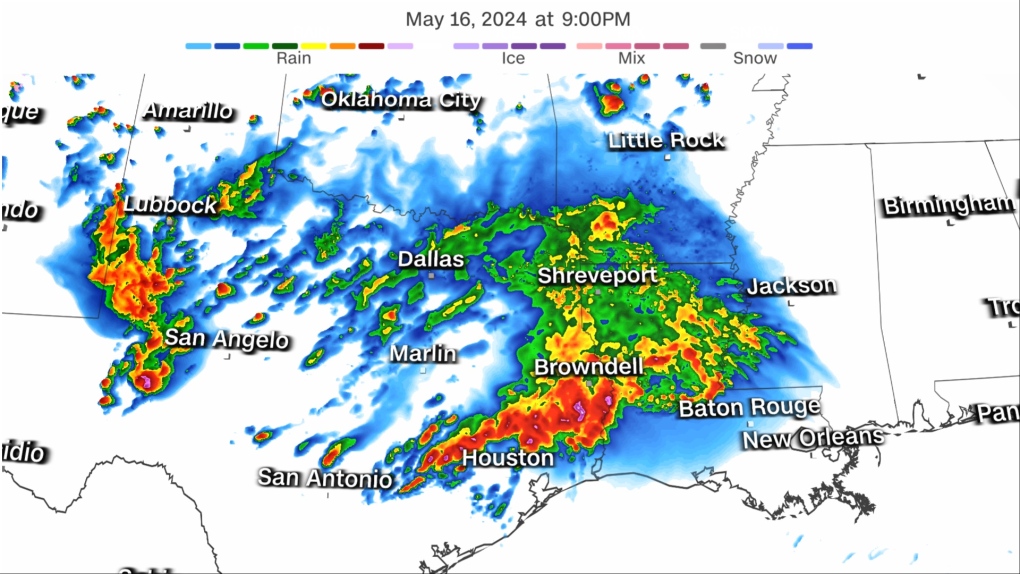
A dangerous, life-threatening flash flooding event is unfolding Thursday as torrential storms pound the already-soaked U.S. South.
A rare Level 4 of 4 high risk of excessive rainfall was issued for parts of eastern Texas and western Louisiana by the Weather Prediction Center Thursday. More than 600,000 people live in the high-risk zone.
High risk days only happen on four per centof days each year, but account for more than 80 per cent of all flood damage and more than a third of all flood deaths in the United States, according to the WPC. Just three other days have reached this concerning mark this year, including the most recent one nearly three weeks ago.
It’s a sign the atmosphere is primed to unload extreme amounts of rain, a phenomenon that is becoming more frequent in a warming world driven by human-caused climate change.
Widespread rainfall totals of two to six inches are expected from Texas to Georgia through Saturday morning. A few spots caught under multiple torrential storms may pick up eight inches or more of rain. It’s not out of the question that one or two spots could record close to a foot of rain in about 48 hours.
Texas and Louisiana have been in the bull’s-eye of seemingly unrelenting rounds of torrential, flooding downpours since the start of April. Rainfall in the waterlogged area over the last two weeks is over 600 per cent of what’s typical, according to the WPC.
Double-digit rainfall totals between 20 and 30 inches over the region in recent weeks have soaked the ground and left rivers swollen, priming the flood threat to extreme levels.
Drenched soils are not expected to soak up any of Thursday’s rainfall, the WPC warned Thursday morning. Widespread flash flooding could begin minutes after heavy rain starts to fall.
Flooding ramps up Thursday but threat persists Friday
Storms, some severe, rumbled to life Thursday afternoon in parts of Texas and prompted flash flood warnings for multiple cities, including Waco. Powerful, heavy storms will push south and east and reach Louisiana and Mississippi late in the day.
Nearly 10 million people are under a tornado watch until 10 p.m. CT Thursday in portions of southeast Texas and southwest Louisiana, including Houston and Lake Charles, La.
A large cluster of thunderstorms moving into the region Thursday afternoon brought with it a flash flood threat from the heavy downpours in addition to the severe storm dangers in the strongest cells. A couple of tornadoes could spawn, scattered damaging wind gusts are likely to reach 70 mph (nearly 113 kilometres per hour) and there may be isolated hail up to two inches in diameter.
A tornado warning was issued Thursday evening in Harris County, Texas, including downtown Houston, according to the National Weather Service – no tornado has been observed yet, but the storms have the potential to produce one. The weather service also issued a severe thunderstorm warning for Houston with the highest-level “destructive” tag. This includes the risk of wind gusts up to 80 mph.
Rainfall rates up to three inches per hour are possible in the heaviest storms, which could lead to life-threatening flash flooding, according to the WPC. Damaging winds, hail and a couple of tornadoes are also possible.
The greatest flooding danger will come as storms train later Thursday. Training storms track through and deluge the same areas over and over, like a train pulling its cars over the same stretch of track.
Serious flash flooding is likely in any areas caught under multiple storms unloading two to three inches of rain per hour. Roadways may quickly become rivers and small streams could easily overflow their banks.
More than 35 million people in the South are under a Level 2 of 4 or Level 3 of 4 risk of excessive rainfall Thursday. Many areas may only endure one torrential storm, but even brief downpours will be enough to cause flooding problems given how wet the South has been recently.
Soaking storms will shift east on Friday and target more of the Gulf Coast.
Significant portions of Mississippi and Alabama are under a Level 3 of 4 risk of excessive rainfall on Friday. A larger area from the Texas/Louisiana border to Georgia and the Florida Panhandle is under a Level 2 of 4 risk.
Drenching storms from Thursday night will likely last into Friday morning for parts of the Gulf Coast. An initial round of flash flooding is likely in the first half of Friday before rain starts to taper off in the afternoon.
Another bout of heavy rain will develop Friday night and continue into the earliest hours of Saturday morning, working over the same areas hit earlier in the day. These storms could produce rainfall rates of two to three inches per hour, and quickly restart or worsen any ongoing flooding.
Extremely wet start to the year
The rain will only add to already extreme rainfall totals in what’s been one of the wettest years to date on record across the Gulf Coast.
Some Southeast cities have recorded more than half a foot of rain above what’s typical for the first several months of the year.
Several dozen cities from Texas to western Georgia are pacing at a top five wettest year to date and at least two cities in eastern Texas are experiencing their wettest year, according to the Southeast Regional Climate Center. Dallas is experiencing its third-wettest year to date while Shreveport, La., is amid its second wettest.
Excessive rainfall has largely eliminated dryness and drought conditions along the Gulf Coast, but it hasn’t come without a cost.
Earlier this month, nearly two feet (0.61 metres) of rain fell in just five days and sent parts of eastern Texas underwater. Hundreds of people and animals were rescued from flooding as some area rivers rose to levels not reached since Hurricane Harvey in 2017.


